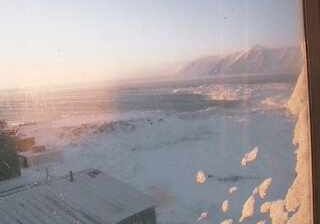
Rancho Cucamonga: Cucamonga Peak
![]() Rancho Cucamonga, Estados Unidos da América
Rancho Cucamonga, Estados Unidos da América
Real-Time Environment
Welcome to the live streaming webcam for Rancho Cucamonga: Cucamonga Peak, perfectly situated in the vibrant region of Rancho Cucamonga, Estados Unidos da América. Watching this live camera allows you to instantly experience the local atmosphere and monitor current climate conditions.

About Rancho Cucamonga
Rancho Cucamonga was a 13,045-acre Mexican land grant in present-day San Bernardino County, California, given in 1839 to the dedicated soldier, smuggler and politician Tiburcio Tapia by Mexican governor Juan Bautista Alvarado. The grant formed parts of present-day California cities Rancho Cucamonga and Upland. It extended easterly from San Antonio Creek to what is now Hermosa Avenue, and from today's Eighth Street to the mountains.
📖 Read more on Wikipedia📍 Location Facts
-
Country
 Estados Unidos da América
- Region Califórnia
- City Rancho Cucamonga
- Coordinates 34.2333°N, -117.5967°E
Have you been to Rancho Cucamonga?
Help the community! Share your experience, tell us about the weather, or upload your own photos from this exact location.